iHikeGPS : Classic Topo Maps app for iPhone and iPad
Unleash the navigation potential of your iPhone or iPad with iHikeGPS! Turn your device into a high-performance GPS receiver, equipped with USGS, US Forest Service & Canadian topo maps. These Classic topo map quads often have valuable back country details that vector maps in other hiking apps dont show.
Even in remote areas with no cell signal, iHikeGPS ensures you always know where youve been, where you are, and where you’re going. Experience the ultimate hiking companion, offering unparalleled track recording, route navigation & accurate Estimated Time of Arrival.
One Low Price! Everything included. No sign-ups, ads, subscriptions or in-app purchases. Completely respects your privacy.
Discover the limitless possibilities of iHikeGPS while hiking, backpacking, biking, canoeing, geocaching, camping, sightseeing, 4WD exploring & hunting. Recommended as the top choice in “Essential Gear for Safe Hiking”, its a must-have for outdoor enthusiasts.
TRACKS, WAYPOINTS & ROUTES
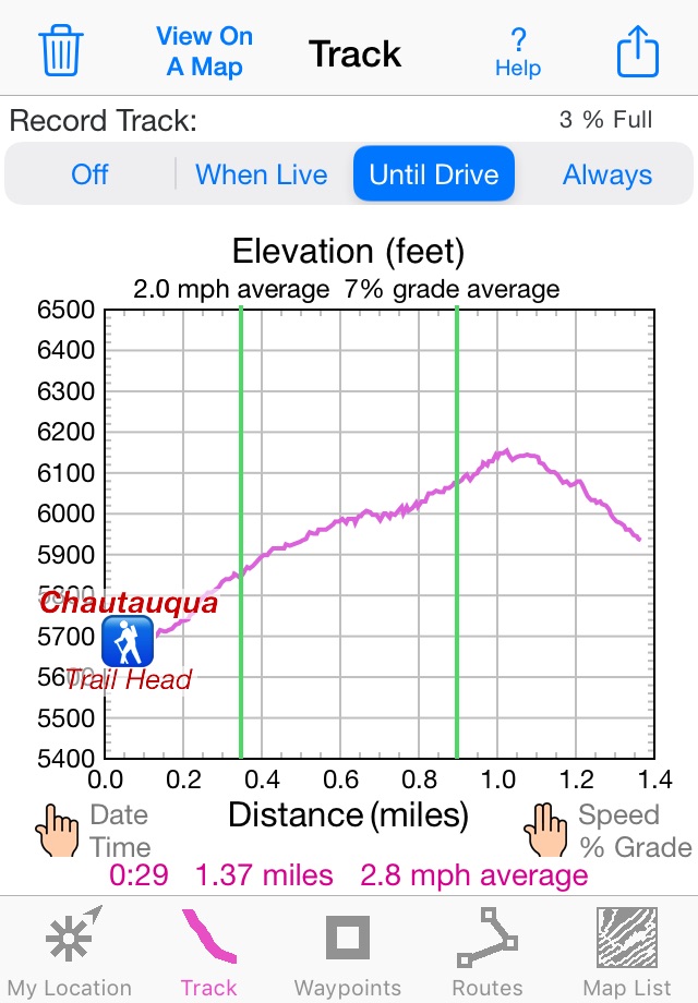
Record tracks as you hike, even in the background. View them on the map with a Trip Timer & Odometer.
View elevation graphs of your tracks & routes. Show date, time, average speed and % grade. Measure the area inside a closed path.
Mark waypoints precisely using topo or satellite maps, place names or addresses, geotagged photos or by projecting from a known point.
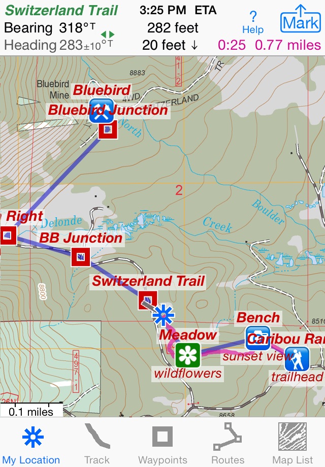
Set a quick GoTo waypoint or a full route & see the heading, direction, distance, elevation change and Estimated Time of Arrival at your destination & intermediate waypoints along the trail.
Create customized routes using waypoints, recorded tracks, or imported GPX, KML or TCX files. Advanced route editing.
Send waypoint, route, track & map list files via AirDrop, eMail, Messages or iCloud Drive.
View the sun & moon position, rise times, & set times for any date & place on earth.
Send data to other apps such as Google Earth.
TOPO MAPS AT NO EXTRA COST
USA: Newest US Forest Service FSTopo 24K maps
USGS 24K maps for all 50 states, Guam, Puerto Rico & the US Virgin Islands
USGS 250K & 100K (63K for Alaska) maps for all states
Canada: National Resources Canada 50K maps for all areas south of 50° latitude. For Alberta, British Columbia & Newfoundland, coverage extends to 54° latitude.
Download using WiFi or cell service. Our maps are optimized to download faster & use less storage memory. Store up to 2200 maps to use in the wilderness without cell service.
These beautiful richly detailed offline topographic map images stitch together for seamless coverage across map boundaries.
Print & Share map images overlaid with waypoints, routes & tracks.
Measure distance and direction between any 2 points.
USE THE UNITS YOU PREFER
Miles, Nautical miles or Km
Feet or Meters
Degrees, Degrees/Minutes, Degrees/Minutes/Seconds, UTM or USNG-MGRS
°True or °Magnetic
HOW TOS
Comprehensive Help in the App
Online Manual on iHikeGPS.com
Email developer: [email protected]
WHAT OTHERS SAY
“I am VERY impressed!!!…It pretty much blows…, my previous fave GPS app, out of the water. Your track recording features, fast map downloads, and well thought out interface make it a real winner. Its very sophisticated software, and makes my iPhone just about as good as $600 Garmin… Actually better, in a lot of ways”-John in OR
“Perfect for anyone camping, fishing & hiking, itll provide great detail when you need it the most…for anyone who takes the great outdoors seriously”-Davids review
“thank you for developing IHIKE GPS…what a great product it is. I am impressed!…I use it hiking, biking, skiing & Jeeping”-Ammon in CO
DEVICE REQUIREMENTS
Use iHikeGPS on any iOS device even if you dont have a cellular data plan for it. iPhones & WiFi+cellular iPads support full navigation. WiFi-only iPads & iPod touch can view maps, but require an iOS-compatible external GPS receiver to show your location & record tracks.
Join thousands of satisfied users who rely on iHikeGPS for their outdoor adventures!
Pros and cons of iHikeGPS : Classic Topo Maps app for iPhone and iPad
iHikeGPS : Classic Topo Maps app good for
This is the best app ever.
Made by professionals for real users.
Acts like a handheld gps reciever.
Nothing unnecesesary inside.
I have used this app twice at the Daniel Boone National Forest (in the Red River Gorge area). There are some places here with a well deserved reputation of being impossible to find unless someone who knows how to get there takes you. Well, I have made it to two of these destinations now by using this app. If you are a hiker who likes to go off the beaten path you need this app. Weve all spent lots of money on our hiking and camping gear and seriously this will be the best 10 bucks you ever spend.
For the average person, this is a great app for hiking. You can print maps, but you may not print maps with UTM or lat long grids on the edges. That is a problem if you want to print a map to take with you along with your compass. If you could print with location grids, you can navigate with your compass much more effectively when your phone fails you in the wilderness. Notice I said will fail you. DO NOT TAKE THIS PROGRAM AND PHONE AS YOUR PRIMARY NAVIGATION IN TO THE WILDERNES. You want a map and compass for your primary in a wilderness enviroment. THis is great to take with you once you know how to use it. I would give 5 stars if you could print with utm grids on the maps, but you cant. Make no mistake, I like this, but it is not a professonals program.
We have had the prior version for about two years. We use this app frequently for hiking, canoeing, and biking. It has helped us make decisions on quite a few occasions. The price is right, and I like that there is no ongoing fee. Once we got through the initial education, it has been easy to use. Ive recommended it to several friends. One of them has a fancy dedicated GPS, yet bought iHike and likes it.
I purchased both iHike and iSail apps this year and they are both TERRIFIC! They were both easy to download and easy to use. I used iHike in Colorado while horseback riding in the Gunnison National Forest. 80 miles of unmarked trails in an area that was "off the grid"! No problem for this app. I downloaded the maps prior to the trip and the app worked flawlessly. I used the app extensively to track my path into the forest. With the path recorded, it was much easier finding my way back home! I still brought hard copy maps and a compass as backup, but the iHike app was my principal source of navigation. 9 days of riding on unmarked trails and I never got lost. Thanks for making such great apps!
I have used this app extensively for backcountry navigation. Often I am where there are no trails. Compared to using a map and compass it feels like cheating. I always know exactly where I am and which direction I am facing. This app has saved me countless hours of wandering trying to figure out how to get where I want to go.
Some bad moments
Please do not sell this app without warning! Its useless outside USA, so is it your intention to take money from users allover the world, anyhow?
I am very upset that you do sell something on the canadian store that does not have canadian maps .
Horrible app! I want my money back!!!! Maps in my area are well over 25 years old and not accurate!!! I would not recommend this to anyone. When I contacted the developer he said it didnt matter as terrain didnt change that much overtime. He must be in prison where there is very little change over time in terrain, because terrain where I live is constantly on the move.You couldnt find your way out of a one door broom closet with this!!!!!
Ive bought and tried several other (more expensive) iOS hiking navigation apps, and this is by far the best one. Good map orientation, ascent profile, and route history support. Also unlike other apps this one doesnt make you register for an account.
Nice interface and easy to use BUT the maps are from 1929!!! 1929 folks! These dont show man made lake that have been here for the last 35 years because the maps are from 19 freaking 29!!!
To the developers who just nabbed $8 from me... You... Are... Evil.
The user interface is pretty bad. To download a map takes 5 steps and after a single quad has been downloaded, you have to start from ground zero to get the next map. Tedious and DOS-like. The index map SHOULD show a grid of maps and the user simply selects the quad or range of quads and click install.
After the maps are installed you can only view one quad at a time. If your trail or destination crosses quads, you have to leave the current map and go to another. Hardly elegant or practical when trying to navigate along a map boundary or want to see a larger overview. This is the only mapping app I have seen that doesnt have the capacity to mosaic adjoining quads. The only time I use this any more is when I need to view USFS quads.
My go-to topographic app is TOPO. It is cheaper, quicker, WAY more intuitive and much more robust. There may be better apps out there, but iHikeGPS isnt one of them.
Usually iHikeGPS : Classic Topo Maps iOS app used & searched for
parks canada,
forest maps,
topo maps,
us forest service,
topographic maps,
i-service,
parks canada – national app,
and other. So, download free iHikeGPS : Classic Topo Maps .ipa to run this nice iOS application on iPhone and iPad.